Publications
Al-Mudayrib, Al-Qabil: Documentation and Heritage Management and Development Plan
Bandyopadhyay, S., Quattrone, G., Goffriller, M., et al., 2014. Al-Mudayrib, Al-Qabil: Documentation and Heritage Management and Development Plan.
Summary
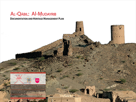
This Documentation and Heritage Management Plan is dedicated to the large and well-known oasis settlement of Al-Mudayrib and builds upon the extensive fieldwork documentation carried out on site, as well as on the interim field report submitted in February 2014. Alongside providing comprehensive drawn documentation resulting from the survey carried out in Autumn 2013, this report includes a Master Plan which addresses issues of heritage management, conservation and development, as well as approaches for its implementation.
The Master Plan illustrates zones and categories of development and conservation to be carried out, which builds on a statement of significance, and assessment of the state of conservation and the threats to heritage management at Al-Mudayrib, drawing on the experiences of researching and developing Master Plans for Hārat al-Yemen, Izkī (2011) and Hārat al-Aqr, Bāhla WHS (2012) among others. The report also includes a comprehensive inventory of structural and non-structural defects present at the settlement as well as a study of the oasis context.
The Master Plan is informed by extensive documentation, analysis and interpretation of the urban structure, morphology, building typology and social conditions of the present and the immediate past.
On this basis, a culturally and technically informed development plan is proposed, which advocates a sustainable revitalization centred on re-habitation, heritage tourism, education, training and skill development programmes with emphasis on traditional knowledge of the built environment and the crafts. As already suggested in previous submissions for Birkat al-Mawz, Fanja, Izkī, Ibri and Bahlā, here too the intention is to move away from an entirely tourism-focused development and towards a more sustainable alternative. Key zones are identified in the Master Plan for protection, restoration, rebuilding, consolidation and redevelopment.
Due to the current degree of habitation of Al-Mudayrib, with over 80% of the dwelling still inhabited, it was decided to pursue a selective approach to the documentation of the site. Relying greatly on aerial photography and drawn documentation the key buildings of the hārah were surveyed in a detailed fashion, together with an extensive survey of the oasis, palm groves and falaj network.
| Author(s) | Soumyen Bandyopadhyay Giamila Quattrone Martin Goffriller |
| Country | United Kingdom |
| Language | English |
| Subject | Documentation and Heritage Management |
| Area covered | Oman |
| Publisher | Ministry of Heritage and Culture, Oman |
| Submission date | 2014 |
| Type | Report |